1. Overview: what the M4E actually is
Released in January 2025, the DJI Matrice 4E is DJI’s direct answer to a question that professional survey operators have been asking for years: can you get M300-class data quality in a sub-1.5 kg foldable airframe that a solo operator can manage without ground crew?
The short answer, after operating one across Guyana’s coastal belt and interior, is yes — with important caveats that no dealer review will tell you.
The M4E sits in a specific product tier. It is not the M300 RTK. It does not support swappable payloads or dual-operator configuration. It is not designed for long-endurance BVLOS corridor mapping. What it is designed for is high-efficiency single-pilot survey operations: fly, process, deliver. For solo operators serving mining, O&G, and construction clients, that mission profile is exactly right.
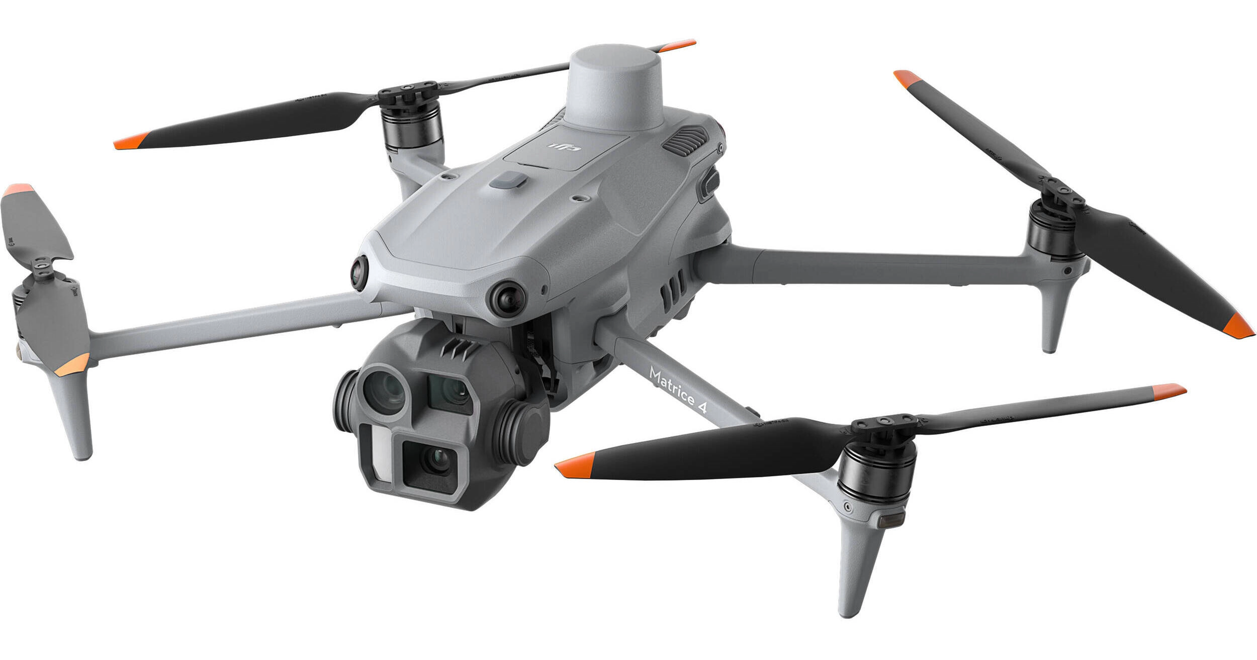
The aircraft is built around a 20 MP 4/3-inch CMOS sensor with a mechanical shutter — the single most important feature for mapping quality. Rolling shutter distortion is the hidden enemy of photogrammetric accuracy in fast-moving survey aircraft, and the mechanical shutter eliminates it entirely. DJI pairs this with 0.5-second shooting intervals and flight speeds up to 21 m/s, enabling coverage of 2.8 km² in a single battery.
The multi-sensor payload stack adds a 70 mm medium telephoto and 168 mm telephoto, both 48 MP, giving the platform genuine dual-role capability: map the site on the wide camera in the morning, switch to the tele cameras in the afternoon for infrastructure inspection. This matters operationally for clients who want both deliverables from a single mobilisation.
2. Key technical specifications
The table below covers the specifications most relevant to professional survey work. Full DJI specifications are available at enterprise.dji.com/matrice-4-series/specs.
| Parameter | Specification | Field relevance |
|---|---|---|
| Wide camera sensor | 4/3-inch CMOS, 20 MP, f/2.8–f/11 | Larger sensor = better dynamic range in harsh tropical light |
| Shutter type | Mechanical, 2–1/2000 s | Eliminates rolling shutter artefacts in fast survey flight |
| Shooting interval | 0.5 s (JPEG) at full 20 MP | Enables high-speed lawnmower passes without coverage gaps |
| Max survey speed | 21 m/s in mapping modes | Cuts mission time significantly vs older platforms |
| Area per flight | 2.8 km² (ortho mode, single battery) | Practical for most mining stockpile and construction sites |
| RTK module | Integrated, L1/L5, GNSS+Vision fusion | No external RTK add-on required; critical for solo ops |
| PPK support | Yes — raw GNSS log, DJI Terra offline | Viable in CORS-free environments such as Guyana’s interior |
| Base station compat. | DJI RTK 3 (D-RTK 3) | Direct integration, fast fix acquisition |
| Max transmission range | 25 km (FCC), 12 km (CE) | Practical for large open-pit mine coverage |
| Max flight time | 49 min (rated), ~38–42 min (field) | Tropical heat reduces effective time; plan conservatively |
| Operating temperature | −10 °C to +40 °C | Upper limit relevant in Guyana; monitor in extended heat |
| Wind resistance | Up to 12 m/s (Level 6) | Adequate for coastal Guyana; pre-check for interior missions |
| IP rating | IP54 (aircraft) | Splash-resistant, not submersible; adequate for rain squalls |
| Take-off weight | ~1.42 kg (standard propellers) | Carry-on luggage compliant in most jurisdictions |
| Medium tele | 70 mm, 1/1.3-inch, 48 MP | Detail inspection at safe standoff distance |
| Telephoto | 168 mm, 48 MP, up to 112× hybrid zoom | Infrastructure crack detection, tower and flare inspection |
| Distortion correction | In-camera, <2 px residual error | Reduces Metashape/Terra processing time and error budget |
| Software included | 1-year DJI Terra license | Offline PPK processing; verify renewal cost before Year 2 |
3. Unpacking and first impressions
Replace with your own deployment photo
The M4E arrives in DJI’s standard enterprise carry case — foam-fitted, hard-shell, dimensions that qualify as carry-on on most regional carriers. For an operator working out of Georgetown who regularly charters small aircraft into the interior, this matters. The M300 RTK requires checked baggage; the M4E does not.
Build quality is noticeably more solid than the Mavic 3 Enterprise it succeeds. The foldable arm locks are positive and deliberate — no ambiguity about whether the aircraft is fully unfolded and locked. The IP54 rating is felt in the fit of the battery compartment and port covers, not just stated on the spec sheet.
The DJI RTK 3 base station is the pairing DJI intends, and the integration is tight. Setup time from case to first RTK fix is consistently under five minutes in open conditions. The RC Plus 2 controller is large and heavy by consumer standards but appropriate for professional field work — gloves-on operability, a bright screen in direct equatorial sunlight, and the ability to run DJI Pilot 2 natively without a tablet mount.
4. Mapping performance — what the data shows
4.1 RTK accuracy in the field
DJI rates the M4E at ±1 cm horizontal and ±1.5 cm vertical positioning accuracy with RTK enabled and good satellite geometry. In practice, operating with the DJI RTK 3 base on a known point, I’ve seen horizontal GCP residuals consistently inside 2–3 cm on standard survey missions. Vertical accuracy is more sensitive to baseline length and satellite count — in the coastal belt with good sky visibility, ±3–4 cm vertical is achievable without GCPs.
In the interior, where satellite geometry is often partially obscured by tall secondary growth, the picture changes. RTK fix rates are lower on approach to forested site perimeters, and the system correctly reports fix status — you know when you’re operating on a float solution rather than a fixed one. PPK becomes the reliable workflow in these conditions, and the M4E’s raw GNSS logging to DJI Terra handles it cleanly.
One genuine operational consideration: the M4E relies on the DJI RTK 3 (or NTRIP CORS) for corrections. In Guyana, where no national CORS network exists, you are always deploying your own base station. This is standard practice for any serious survey operation here, but operators moving from a region with mature CORS infrastructure should account for the additional setup time and equipment logistics.
4.2 Image quality and photogrammetric output
Replace with your own Metashape or DJI Terra screenshot
The 4/3-inch sensor produces images that both Agisoft Metashape and DJI Terra process cleanly with minimal noise. Flying at 100 m AGL in standard coastal conditions, GSD runs at approximately 2.7 cm/pixel — well inside acceptable tolerances for stockpile volumetric reporting and earthworks cut-fill tracking. At 80 m, this tightens to approximately 2.2 cm/pixel for sites requiring higher resolution.
The factory camera calibration and in-camera distortion correction (Distortion Correction 2.0, residual under 2 pixels) make a measurable difference in point cloud quality. In Metashape, tie point reprojection errors are consistently lower than I observed with the Mavic 3 Enterprise on equivalent missions.
4.3 Coverage efficiency — the 2.8 km² claim
DJI’s 2.8 km² per flight figure is achievable with the 3-directional ortho capture mode, 80% frontal overlap, 70% side overlap, and optimal battery health at low altitude above sea level. In field conditions — partial wind, real-world battery degradation, and conservative safety margins — plan on 2.0–2.4 km² per flight as a working figure for most survey applications.
The GeoNadir independent review made an observation worth noting: the 3-directional ortho mode (which captures oblique images alongside nadir) may not always improve orthomosaic quality compared to pure nadir capture, and flies slower due to gimbal rotation at each capture point. For straight orthophoto deliverables, nadir-only often produces the fastest and cleanest result. Use 5-directional oblique mode when you specifically need 3D model quality — it is genuinely better for that purpose.
5. Field performance in tropical and remote conditions
This section is the one no dealer review covers, because most dealer reviews are written by people who have never operated in ambient temperatures above 35 °C at 90% humidity, or managed a battery pack that’s been sitting in a dugout canoe for four hours before the mission.
5.1 Battery behaviour in high ambient temperature
- Effective field flight time: 35–42 minutes, not the rated 49. In sustained heat with active mapping, plan on 38 minutes as working maximum before the BMS begins conservative discharge limiting.
- Rest time between flights: minimum 10 minutes in shade when running multiple batteries consecutively. DJI’s charging hub manages this correctly — it will not attempt to charge a battery above temperature tolerance.
- Rain tolerance: IP54 provides real protection against sudden rain squalls common in the interior. The aircraft handles light rain during active flight without issue; I would not fly in sustained heavy rain.
5.2 RTK fix acquisition: coastal vs interior
On the coastal belt (Georgetown area), with the DJI RTK 3 on a known point and clear sky above 30° elevation, RTK fix is typically achieved in 90–120 seconds. This is operationally excellent — faster than any other platform I’ve used in this region.
In the interior, under partial tree canopy or within forest clearings, fix acquisition takes longer and may downgrade to float solution during flight. My protocol: if fix drops to float during a mapping mission, the affected flight lines are re-flown with PPK as the accuracy method, using the raw GNSS log from both the aircraft and the RTK 3 base.
PPK workflow on the M4E is handled through DJI Terra’s offline processing module. The DJI RTK 3 logs RINEX-compatible observation files. Processing is straightforward: import the drone raw log and base station observation file, set the base coordinates, run. This workflow is reliable and I use it as the primary method on all interior missions regardless of RTK fix quality, as a QA backstop.
5.3 Logistics for remote operations
The M4E’s compact form factor is a genuine operational advantage for interior Guyana deployment. The full kit — aircraft, three batteries, DJI RTK 3 base, RC Plus 2, charging hub, and laptop — fits within two carry-on-scale cases. This is not possible with any comparable-accuracy platform.
6. Performance by sector
6.1 Mining — stockpile volumetrics
Replace with your own mining site capture
For open-pit and alluvial mining stockpile surveys, the M4E is exceptionally well-matched. A typical stockpile yard covering 3–8 hectares can be completed in a single flight at 80–100 m AGL, producing a point cloud with sufficient density for volumetric calculation to ±2–3% accuracy against GNSS rover ground-truth.
For mining clients who require monthly inventory reporting, the consistency of the platform matters as much as single-mission accuracy. The M4E’s integrated RTK and factory-calibrated camera ensure that repeat surveys at the same site are genuinely comparable — there is no inter-mission drift introduced by changing payloads or recalibrating cameras.
6.2 Oil & gas — infrastructure inspection
The telephoto camera stack — 70 mm medium tele and 168 mm tele at 48 MP, with up to 112× hybrid zoom — makes the M4E capable of safe standoff infrastructure inspection at distances that keep the aircraft outside hazard exclusion zones around flare stacks, wellheads, and pressurised lines. At 250 m standoff, the 168 mm camera resolves surface defects in the 2–5 cm range depending on lighting conditions.
For pipeline corridor orthophoto — producing a georeferenced strip map of a right-of-way — the wide camera performs the survey role cleanly. The medium tele can be used for targeted inspection of specific features identified in the initial wide-camera pass, within the same mission. This dual-pass workflow maximises billable deliverables per mobilisation.
6.3 Construction — earthworks and progress monitoring
Construction is the most operationally straightforward sector for the M4E. The DJI Terra cut-fill comparison tool, using the M4E’s survey-grade georeferenced output against an imported design surface, produces client-ready earthworks progress reports directly. For construction clients new to drone survey data, this turnkey reporting pathway significantly reduces the client education component of the engagement.
7. How independent testing compares
DJI Enterprise’s own comparison against the Matrice 350 RTK with Zenmuse P1 — conducted by SURVAIR founder Richard Butkus III over a 40-acre site with 13 known control points — found that the M4E achieves consistency and precision competitive for standard survey applications. The P1 system retains an edge in absolute accuracy on larger sites when GCPs are integrated, which is expected given the P1’s larger sensor and longer focal length.
For solo operators serving the majority of commercial survey work — sites under 50 hectares, clients who need ortho and volume rather than geodetic-grade absolute positioning — the M4E’s output is fit for purpose.
GeoNadir’s independent review noted that the 3-directional ortho capture mode flew slower and collected more images than pure nadir capture without always improving reconstruction quality. This aligns with my field experience: use nadir-only for fast orthophoto and volume deliverables; use the oblique modes specifically when 3D model quality is the primary requirement.
8. Field operator scorecard
| Category | Score | Operator notes |
|---|---|---|
| Mapping accuracy (RTK) | ★★★★★ | Consistent 2–3 cm horizontal in good conditions with DJI RTK 3 |
| Mapping accuracy (PPK) | ★★★★★ | Reliable offline workflow; essential for CORS-free environments |
| Coverage efficiency | ★★★★★ | 2.0–2.4 km² practical per flight; excellent for solo operators |
| Image quality | ★★★★★ | 4/3 sensor + mechanical shutter: best-in-class for this platform tier |
| Build quality / IP rating | ★★★★☆ | IP54 handles field conditions well; not M300-class durability |
| Tropical heat performance | ★★★★☆ | 38–42 min real-world battery in Guyana heat; plan accordingly |
| Remote logistics | ★★★★★ | Carry-on deployable; transformative for interior operations |
| RTK fix acquisition speed | ★★★★★ | 90–120 sec to fix on coastal belt; slower in obstructed interior |
| DJI Terra integration | ★★★★☆ | Solid PPK and processing pipeline; Year 2 license cost to budget |
| Value for solo operator | ★★★★★ | Best ROI in this accuracy class for single-pilot commercial work |
9. Limitations worth knowing before you buy
No platform is without trade-offs. These are the limitations that matter for professional survey operators — not the trivial ones that pad consumer review copy.
- No swappable payload. The M4E’s integrated sensor array is fixed. If your workflow requires LiDAR penetration through dense vegetation canopy, you will need a different platform.
- DJI Terra Year 2 cost. The included one-year license is generous, but factor in the renewal cost before quoting multi-year contracts. Agisoft Metashape is an effective alternative.
- No CORS in Guyana. Regional infrastructure gap, not an M4E limitation — but you must deploy your own base station on every mission. Budget for the DJI RTK 3 as a paired purchase.
- Battery count for full-day operations. Three batteries cover approximately 2–2.5 hours of active flight. For large-area surveys requiring more than 10 km² in a single day, plan for four batteries minimum.
- Heat and direct-sun storage. Do not leave batteries in direct sun between flights in tropical heat. Thermal management is the most important daily discipline.
- RC Plus 2 screen glare. In direct afternoon sun at low angles, screen visibility is reduced. A hood or adjusted approach to sun direction in mission planning mitigates this.
10. Verdict
The DJI Matrice 4E is the right platform for the majority of professional solo UAV survey operations in mining, O&G, and construction. Its combination of integrated RTK, mechanical shutter mapping camera, genuine compact form factor, and multi-sensor inspection capability represents a step change from the generation of enterprise drones it replaces.
For operators in markets like Guyana — where CORS infrastructure is absent, logistics are demanding, and clients need professional-grade deliverables on a solo-operator budget — the M4E is currently the best platform at this price point. The DJI RTK 3 base station is a required pairing, not an optional upgrade.
The limitations are real but manageable: plan battery logistics for high ambient temperature, budget for post-Year-1 Terra licensing, and accept that PPK rather than live RTK will be your accuracy method on interior missions. None of these reduce the platform’s capability — they define the operational discipline required to use it at its best.
Buy it. Pair it with the DJI RTK 3. Build your PPK workflow in DJI Terra before you need it in the field. Run three batteries minimum. The M4E earns every dollar of its price on commercial survey work.
11. Where to buy and what to budget
The M4E is available direct from DJI Enterprise and through authorised enterprise dealers. Pricing as of early 2025 sits at approximately USD 5,000–6,000 for the base combo. For a working survey kit, budget for: